While regarded now largely as a provider of breakdown assistance and motor insurance, the Automobile Association had a wider remit in the past. It installed signs to direct motorists and warn them of hazards. And in the 1920s, it got into the telephone business in the UK and the newly-independent Irish Free State.
The AA began to install phone boxes which members could use to summon help in the event of a breakdown. While connected to the regular telephone system, they were not public telephones and had to be unlocked with a key which was issued by the AA to its members. There was no coinbox mechanism – members could make a local call for free, but for other calls they were expected to leave the appropriate amount in an ‘honesty box’1 or reverse the charges. In the days when all trunk and – in many places, local – calls were connected by an operator, this was pretty easy to monitor.
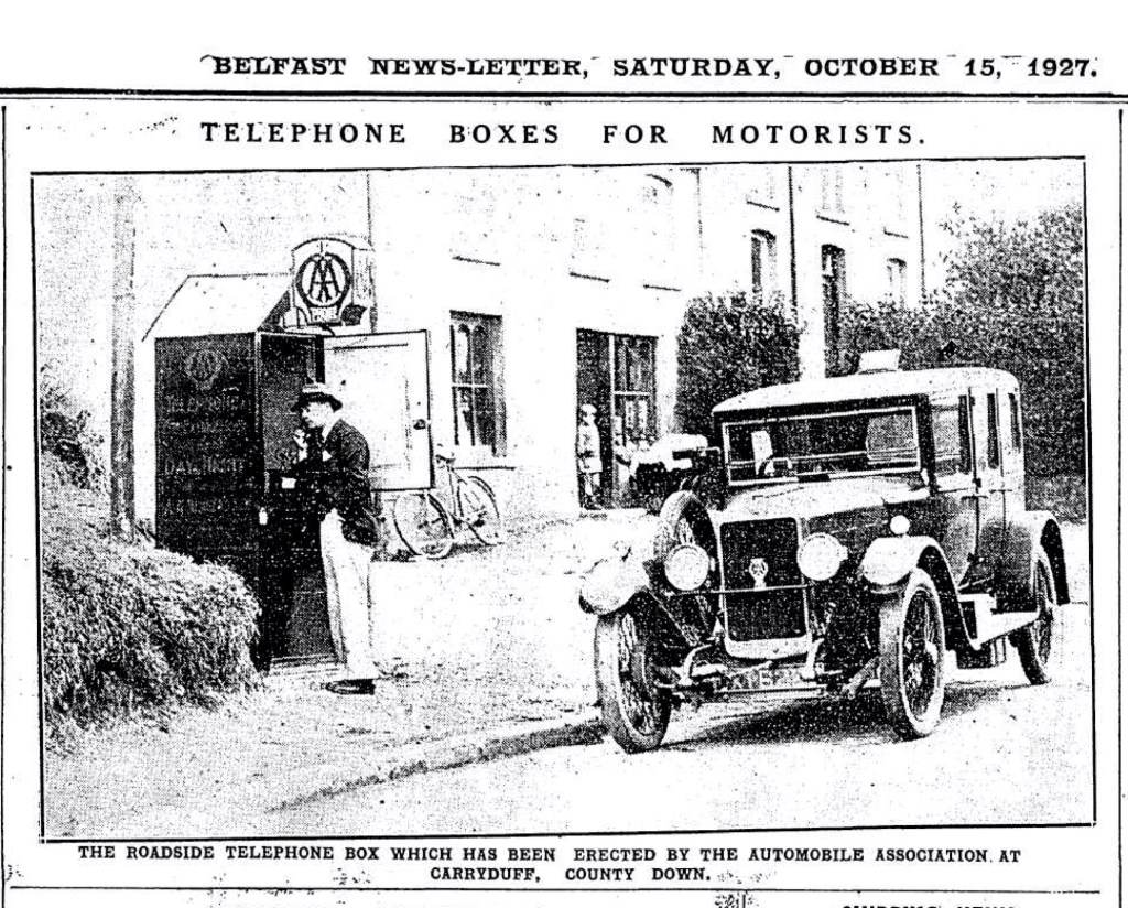
The network was extended to Ireland in 1927, with the first roadside boxes being installed in Carryduff, outside Belfast and Shankill, Co. Dublin. In addition to a telephone, the boxes displayed the phone numbers and addresses of the local doctor, police station, approved hotels and garages. They also contained, at different periods, first-aid kits, fire extinguishers and touring maps.

Within a few weeks, the Irish Independent was reporting that ‘Extensive use has been made by motorists of the roadside telephone stations… and the number of calls registered indicates that this latest addition to the amenities of the road fills a long felt want2.‘
In a 1949 review of the AA’s members’ Handbook, the Cork Examiner mourned that the association’s …’telephone boxes are not as general in Ireland as in the other island, but there are several on important routes and junctions‘3.
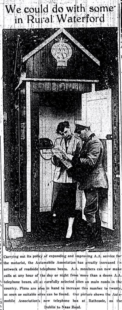
The network in Ireland was expanded in the early 50s so that by 1954, there were over 12 roadside boxes with a stated aim of reaching 204. In the end, the network grew to about 34 boxes across the island, split equally between the two jurisdictions5. It was a pretty meagre number, representing less than 4% of the total network of 862 boxes across Great Britain, both parts of Ireland, the Isle of Man and the Channel Islands.
The heyday of the AA roadside telephone box was the late 50s and early 60s. By the late 1960s some were being removed6, though members were still issued with keys.
As a child I was fascinated by the key on my dad’s keyring with the AA logo on its diamond-shaped bow. My father explained how it could be used to open one of these boxes, but we never seemed to see one on our travels from Dublin, which makes me think that many had been removed by the late 1960s. I remember some excitement when we finally spotted one, I think, on the old N1 at Blakes Cross, probably box 648 on the list below.
One reason for their removal was the expansion of the public telephone network which made the AA telephones increasingly redundant. The growing motorway network, with its own emergency telephone system, removed traffic from the roads provided with AA boxes.
The death-knell was sounded by the arrival of the mobile phone as a mass product in the 1990s. The AA decommissioned its last remaining boxes in the UK in 2002; it is likely that the last boxes in Ireland were removed well before that.
Quietly and unmourned, the AA’s contribution to telecommunications history draw to a close.
For more about the history of telecommunications in Ireland, check out my other blog posts.
List of AA telephone boxes in Ireland
| Box No | Name | Telephone No. | Location | Installed | Notes |
| ? | Carryduff | Unknown | Near the junction of the A24 and A7 | 1927 | 1 |
| 643 | Killeen | Newry 2500 | Newry – Dundalk A.1 / 3 miles from Newry | ||
| 644 | Ballcarry | Whitehead 2232 | Belfast – Larne A.2 / 1 3/4 miles northwest of Whitehead | 1928 | 7 |
| 645 | Loughbrickland | Banbridge 2116 | Newry – Banbridge A.1 / 3miles south of Banbridge | 1930 | 8 Preserved at the Ulster Folk and Transport Museum |
| 646 | Culcrum | Cloughmills 209 | Ballymena – Ballymoney A.26 / Ballycastle A.44 | 1930 | 8 |
| 647 | Shankill | Bray 2644 | Dublin – Bray T.7 / Dalkey T.44 / 1 3/4 miles north of Bray | 1927 | Removed in late 1960s6 |
| 648 | Dawsbridge | Swords 203 | Dublin – Drogheda T.1 / Skerries L.90 | ||
| 649 | Dunkettle | Glanmire 44 | Cork – Fermoy T.6 / Midleton T.12 | ||
| 671 | Roughfort | Glengormley 316 | Belfast – Antrim A.6 / Roughfort – Ballycraigy (Unclass) | 1952 | 9 |
| 672 | Drumgor | Lurgan 3104 | Lurgan – Portadown A.3 / 2 1/2 miles northeast of Portadown | 1952 | 9 |
| 673 | Fivemiletown | Fivemiletown 232 | Clogher – Fivemiletown A.4 / 1 mile east of Fivemiletown | 1952 | 9 |
| 674 | Ballykelly | Limavady 207 | Limavady – Londonderry A.2 / 4 1/2 miles west of Limavady | 1952 | 10 |
| 675 | Damhead | Coleraine 2596 | Coleraine – Ballymoney A.26 / 220 yds. southeast of Loughan – Ballybogey (Unclass) / 3 1/2 miles southeast of Coleraine | ||
| 676 | Tullyhinan | Banbridge 2280 | Banbridge 2280 – Dronmore A.1 / 2 1/2 miles northeast of Bandridge | 1952 | 9 |
| 690 | Killcullen | Kilcullen 41 | Naas – Athy T.6 / Carlow T.51 | ||
| 691 | Curragh | Curragh 69 | Naas – Kildare T.5 3 3/4 miles east of Kildare | ||
| 692 | Cahir | Cahir 273 | Cahir – Mitchelstown T.6 / 3 miles southwest of Cahir | ||
| 693 | Coachford | Coachford 33 | Cork – Macroom T.29 / 2 miles west of Coachford | ||
| 694 | Patrickswell | Patrickswell | Limerick – Mallow T.11 / Limerick – Tralee T.28 / 6 1/2 miles southwest of Limerick | ||
| 695 | Meeting-of-the-Waters | Avoca 30 | Rathdrum – Arklow / 2 1/4 miles from Avoca / 4 1/4 miles from Woodenbridge | Removed in late 1960s6 | |
| 696 | Dungarvan | Dungarvan 143 | Waterford – Dungarvan T.12 / Lismore T.30 | ||
| 697 | Mullins Cross | Dunleer 35 | Drogheda – Dundalk T.1 / South of Junction Mansfieldtown (Unclass) | ||
| 698 | Dunboyne | Donboyne 261 | Dublin – Navan T.35 / 170 yds. from Dunboyne junction into Meath / 1 mile from Dunboyne / 8 miles from Dunshaughlin | ||
| 699 | Moate | Moate 39 | Moate – Kilbeggan / 1.9 miles east Moate T.4 | ||
| 700 | Rathcoole | Rathcoole 289247 | Dublin – Naas T.5 / 3/4 mile from Rathcoole | ||
| 701 | Collooney | Collooney 24 | Boyle – Collooney T.3 / 1 mile approx. south of Collooney at Toberscanavan | ||
| 768 | Verner’s Bridge | Anaghmore 274 | Portadown – Dungannon A.4 / Maghery B.196 | ||
| 769 | Springwell | Coleraine 3576 | Coleraine / Limavady A.37 / 7/3/4 miles southwest of Coleraine | ||
| 790 | Beltony | Newtownstewart 287 | Omagh – Newtownstewart A.5 / 3 miles Newtownstewart | ||
| 791 | Bready | Londonderry 3879 | Londonderry – Strabane A.5 / 6 1/2 miles southwest of Londonderry | ||
| 851 | Leixlip | Lucan 231 | Dublin – Galway T.3 / 1/2 mile west of Leixlip | ||
| 881 | Binmore | Derrygonnelly 249 | Enniskillen – Belleek A.46 . 12 miles northwest of Enniskillen | ||
| 909 | Merlin Park | Galway 4438 | Galway – Dublin / 9 miles from Athenry / 18 1/4 miles from Louch Ben | ||
| 914 | Glenshane Pass | Dungiven 289 | Maghera – Dungiven A.6 / 6 1/2 miles from Maghera / 6 1/2 miles from Dungiven |
References
1 Belfast Newsletter, 15 October 1927
2 Irish Independent, 11 November 1927
3 Cork Examiner, 12 May 1949
4 Waterford News and Star, 10 September 1954
6 Wicklow People, 30 December 1999
7 Londonderry Sentinel, 01 May 1928
8 Belfast Newsletter, 07 August 1930
9 Belfast Telegraph, 01 February 1952
10 Londonderry Sentinel, 01 April 1952

Hi, am trying to find info on AA box at Kilmacthomas Co. Waterford on main road(N25). Had seen this sentry box on numerous occasions as a youngster, late 60’s early 70s. It was on right hand side of road heading for Dungarvan. Do not recall number. Do not know when it was removed. Any info would be greatly appreciated. Thank You
LikeLike
Hi Brian,
Thanks for your comment.
Could this have been box 696, described as “Dungarvan: Waterford – Dungarvan T.12 / Lismore T.30” ? I think this would have been on the Waterford side of Dungarvan where the N72 braches off the N25, though this is further west than where you describe.
Deryck
LikeLike